
Today’s featured photo is from Snowshoe last weekend. Will we see snowmaking this weekend?
It’s time for another Thursday roller coaster.
Today kind of feels like déjà vu as the set-up is nearly the same as last Thursday.
Rain will move through the area this afternoon on the leading edge of a cold front, and temperatures will quickly fall as the front moves through.
While the forecasted drop today isn’t as dramatic as last week’s, tomorrow’s high will be half of today’s highs with wind chills reaching below zero in some locations.
On top of the cold, there is a chance for some natural snow across the region, but nothing major – less than an inch is expected. It’s still snow though and we will take it.
Tonight and Friday night should provide snowmaking opportunities for the resorts who choose to take advantage.
The West Virginia resorts may not reach the 30’s during the day on Friday so Snowshoe will be cranking out snow in prep for the Nov. 22 season opener.
However, Saturday and Sunday may be tougher to get the guns cranked based on the current forecast.
After the weekend, however, we may be back in business with some arctic air on the way. Take a look at this model that Kenny shared inhouse yesterday:
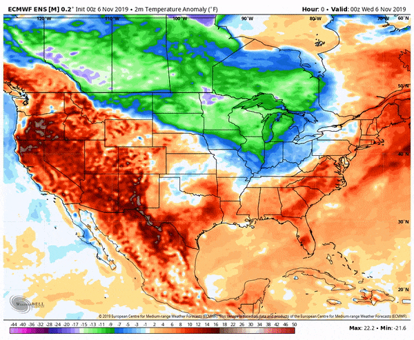
All that cold could make for some stellar Thanksgiving conditions.
Now the important question, will we see the season resume this weekend?
We are in a wait-and-see mode to see what Cataloochee and Sugar plan to do this weekend. The crew at Cataloochee are still hoping to resume operations on Saturday, but it is dependent on how big that snowmaking window pans out to be tonight and tomorrow.
We should, however, have a better idea tomorrow.
Be sure to follow us over on Facebook, Twitter, and Instagram for the latest news, notes and more.
Until next time, #ThinkSnow!