Story by Mike Doble – [email protected]
I was visiting beautiful Blacksburg, Virginia on Saturday as my daughter is hoping to get into Va Tech’s amazing architectural program there. She and I were lamenting the fact that we were both missing out on Beech Mountain’s opening day and from all indications it was pretty darn nice on Saturday.
KDog, Mellow, Pink, Jam and several others were taking in Beech’s first day on the snow for the season and from their expert intel – it was a great first day.
 <Kenny Griffin took this nice shot of Jasen Vioral (Mellow Yellow from the messageboard) on Saturday. Nice trench Jasen!)
Obviously I also missed more than a dozen emails from some of our less-informed visitors who seemingly have our Christmas-to-New Years Holiday ski period already written off as anywhere from terrible to nonexistent.
Look at the title of this morning’s story. I’ll repeat it – It’s Sunday, December 4th.
There are 21 days til Christmas and those three weeks will be filled with numerous snowmaking opportunities and some good natural snows and things will be just fine by the time many of you pack your bags and head to the mountains for the Holidays. So come off the ledge; there’s no need to jump. There’s no need to cancel your reservations. If you do, you’ll be kicking yourselves in the butt.
To better explain – let’s review!
 <Cataloochee Ski Area this morning! Looks pretty good to me!
It has only been cold enough to make snow on SEVEN of the last TWENTY EIGHT days since November 10th at MOST of the ski communities. Sugar and Cat made snow and opened November 11th after 24 hours of snowmaking. They both operated that weekend (with Sugar going an extra day) before closing. The snow melted away with mild temps following those first few days. (Snowshoe made snow first and was stockpiling with no intention of opening that early.)
You can almost DITTO the above for the next three weekends as both Sugar, Cat and Snowshoe made snow at each opportunity and Sugar & Cat opened for the weekends of November 19th and 26th…and both entertained guests who enjoyed the slopes that were open. Rains and mild temps destroyed the trails during the weekdays of each of the last four weeks.
Beech Mountain Resort got into the act this past week and made snow for two days, and got 4" of natural snow and they opened yesterday. Cataloochee, Sugar and Beech Mountain will play today. We don’t have word yet about Beech, but at the very least Cataloochee will close until next weekend. The weather could force Sugar and Beech to close by Tuesday if not sooner as heavy rain is forecasted Monday into sometime Wednesday.
So THUS FAR we’ve seen a cycle within the last month that has only allowed for 1-2 days of snowmaking mid week – and resort openings for those subsequent weekends. The important thing to note is that the ski areas were able to open after ONLY a day of snowmaking. Two days of snowmaking and things looked remarkable. That is a testament to the technology and snowmaking plants that are in place at each of the ski resorts in our region.
So we’ve seen skiing and snowboard at the North Carolina ski areas within EACH of this and the previous three weekends. That’s FOUR weekends in a row of play on the snow!
If the ski areas can get 3-7 days of snowmaking…LOOK OUT!
…and they will. October and November are traditionally spotty in terms of temps. As we get into December, we can always expect more consistent cold temps and some snowfall. Case in point is the forecast for the coming week. After the showers come and go Monday-Tuesday – we should see some really cold temps hit by Wednesday night. As an example, here are the forecasted temps for Maggie Valley’s Cataloochee Ski Area:
Wednesday – Showers – Hi 44° Lo 25° (snowmaking)
Thursday – Few Showers – Hi 44° Lo 25°
Friday – Sunny – Hi 47° Lo 26°
Saturday – Sunny – Hi 38° Lo 22°
Sunday – Sunny – Hi 41° Lo 23°
Monday – Cloudy – Hi 44° Lo 24°
Tuesday – Sunny – Hi 47° Lo 24°
So for the week through December 13th things are looking VERY GOOD for as many as seven nights of great snowmaking ops. That will create some serious base depths and lots of trail openings.
The forecast above fits for Beech and Sugar Mountains as well and you can notch it only a degree or so milder for Appalachian Ski Mountain in Blowing Rock. So we should see at least six days of snowmaking through the 13th of December for App. Given those temperatures, Brad Moretz and his team at Appalachian can create a virtual BLIZZARD and have the whole darn mountain open, including some giant jumps in the terrain park.
As we gameplan for the ski areas up into West Virginia and Maryland we’re seeing the same SEVEN nights of snowmaking. It might be a close call as to whether any of the ski areas in West Virginia will open for December 9th or 10th after only two nights of snowmaking prior to that…but if not by December 9th, they will open shortly thereafter (and we will keep you updated). Ditto that for Wisp Resort in McHenry, Maryland.
.jpg) <Massanutten Resort this morning. Resorts north of the North Carolina ski areas are waiting on next week’s cold temps to make snow and open!
<Massanutten Resort this morning. Resorts north of the North Carolina ski areas are waiting on next week’s cold temps to make snow and open!
Where we will probably see some continued trials and tribulations in terms of getting open in the next week will be at the Virginia and Tennessee ski resorts. Temps should get into snowmaking range around December 8th at Massanutten with a borderline low of 28°. The nightime temps from then through December 13th are right in the upper 20s range and there could be some good nights and not-so-perfect nights for snowmaking. However, again, it doesn’t take much for these guys and gals to crank out some snow.
WHAT ABOUT THE NEXT WEEK(S)?
WE’RE FORECASTING A COLD AND SNOWY REST OF DECEMBER AND JANUARY…but read on as we’re still trying to talk some of you down from the ledge.
.jpg) <Back in October Accuweather and many forecasters were talking of stormy and temps from 0-1 degree colder than average.
<Back in October Accuweather and many forecasters were talking of stormy and temps from 0-1 degree colder than average.
Long range forecasts can’t be trusted. Anything more than 5-6 days out becomes rather suspect, however back in October all of the so-called weather experts had our region slated for 1-2° colder than normal and anywhere from about normal snowfall to something close to a "Snowmageddon" for the ski areas from Winterplace north.
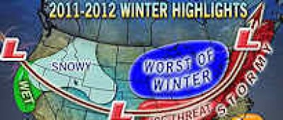
That was October. Now TODAY new information seems to be coming out that says that Winter will be white and wonderful … for Colorado, Montana, Utah and Idaho…with the "Worst of Winter Cold and Snow" across the extreme northern, midwest (Great Lakes). Back in October, our ski region of the Southeast and Mid Atlantic was to expect a STORMY & COLD winter. That had me ready for some skiing!
 The "Worst of Winter" is now bubbled closer, and we’ve lost the "Not as Cold" tagline!>
Fast forward just 30-45 days things are looking pretty much the same for the west and midwest, but for our area we should now expect "STORMY" with temps that some are forecasting somewhat colder than average for the Southeast and mid Atlantic.
Okay some are wavering…but read on.
Before some of you start walking towards the ledge, let me elaborate.
If you’re thinking of heading west – winter will be snowier than usual. Typical of a La Niña year, the harshest cold will blast the northern Plains and northern Rockies. Although this may be the case this season, cold air masses will sink farther south and east at times. Most of the weather gurus are now leaning towards this mode:
Winter in the Northeast will likely lack substantial rounds of long-lasting arctic cold. However, there can still be cold snaps with below-normal temperatures. Overall, temperatures are expected to average out near to slightly above normal – for the NORTHEAST with above-normal snowfall likely across the interior Northeast.
What that should mean for us here in the Southeast and Mid Atlantic is pretty much a crap shoot according to most of the gurus I’ve looked at. With "The Worst of Winter" just west and north of Snowshoe and the West Virginia ski communities, I’d expect that they will get bombed this winter. "Stormy" for that area means lots and lots of snow. If the La Niña scenario brings the typical single jet-streams that we see during those kinds of winters, then we’ll probably see numerous "stormy" setups that will track AVERAGE cold temps into enough moisture to make for a very snowy winter from Winterplace Resort in Ghent, West Virginia to the north.
The temperatures are forecasted to be from about normal to slightly colder than normal for December across the North Carolina mountains and that should make for PLENTY of snowmaking nights (and days) for the period between December 13th and the end of the month. That should bring a smile to all of the ski area management peeps and skiers and snowboarders alike.
With some good natural snows and cold temps, the ski areas in West Virginia, Maryland and North Carolina should be in great shape.
We’re thinking that the North Carolina ski areas will see about normal snowfall for this winter, with some pretty decent ("stormy") snows. One look at the fact that Snowshoe Mountain has already seen 28" of snowfall should support the "Stormy" idea. Thus far Beech has only seen 6" of snowfall and we’re thinking that kind of trend will stay in place most of this winter. If the WV resorts see 200" of snow (very likely) then we can kind of expect around 70-80" of natural snowfall for the NC ski areas. (Again, about normal.) One or two mega-snows could make those numbers tweak up quickly and THAT is what "STORMY" can get you.
As that applies to the Virginia and Tennessee ski resorts, we’re thinking that things could be challenging this winter. However "challenging" could mean bursts of mega snowstorms like the Virginia resorts had two seasons ago. During the 2009-2010 ski season Wintergreen Resort picked up 93" of snow! Most of the snow came from three events with two of the storms dumping more than 30" of snow each. It could be that kind of winter in Virginia with big snows and then some ice and some borderline temps that will make it challenging to make and maintain snow on the slopes.
HERB STEVENS…WHAT’S HE SAY?
 Herb Stevens (in the red jacket) is the self-proclaimed "Skiing weatherman". He’s got a pretty good track record over the years and was bought out by SnoCountry a few years back. They allow him to continue his passion (weather) and throw in the skiing. We have some skiing weathermen of our own including Mike Stinneford in Washington, DC; Brad Panovich of WCNC and Kenny Griffin (our own staff meteorologist). Our guy Brad is a snow bird if ever there was one and although we haven’t gotten him on the slopes that often, he’s always looking for that next flake of snowfall! Our guy Kenny’s passion is FIRST snowboarding and THEN weather and although he’s a snow loving guy himself (and a meteorologist) he’s not quite the "finder of snow" that Brad is. Come to think of it Jim Cantore and Paul Goodloe of THE WEATHER CHANNEL are great skiers. Anyway – back to Herb.
Herb says, "The "polar vortex" is in place right now, and that feature tends to bottle up the lion’s share of the cold air well to the north. A series of jet stream level events will take place in the next week that will lead to a strong trough digging into the middle of the country, and that trough will tap into some of the very cold air swirling around the polar vortex and deliver it to more southern latitudes. That will allow resorts from southern Canada all the way down to the Smokies to finally get some significant snowmaking hours in on the hill, and by the weekend of the 10th, the list of open resorts will be growing by the hour."
NOW WE’RE TALKING…so what about the entire winter around here, Herb?
His data seems to suggest, "…a bit of a roller coaster season in the East." However, the good news is that Herb’s research also is leaning towards temperatures that will play around 1-2° BELOW AVERAGE for the Southeast and Mid Atlantic during December and January – while February could be about normal to a degree or so ABOVE AVERAGE.
…OH GOOD LORD…WE’RE BACK ON THE LEDGE AGAIN! NOT SO FAST GRASSHOPPERS!
Herb writes, "Now, I know this looks like a relative heat wave, but keep in mind that although daily normal temperatures will be on the rise during the second month, they will still be low enough to support snow events." (…and snowmaking!)
So, in summary, we are entering another La Nina winter, but this version does not look as though it will be as strong as last year. It brought us November snows (from 6-28" of snow to the region.)
According to most of the weather gurus we trust, we should see cold develop in the East by the end of the month, with a very wintry month on the way for the rest of December.
See…there’s no reason to jump just yet. KEEP THOSE RESERVATIONS!
Hopefully those of you who emailed me will understand that it just doesn’t take a lot of cold for our talented ski areas to cover the trails. If things hold the way they are looking, we’ll be good to go once we get into next week and beyond.
I’m going out of a limb here and saying you can COUNT ON SKISOUTHEAST! We wouldn’t steer you guys wrong. God? You listening? Good!
Now go make those reservations if you haven’t. Keep ’em if you got ’em. We’ll be just fine.
Feel free to email me your thoughts, photos, comments, photos, videos – whatever ya got to: [email protected]