Before I get to the good news, let me go ahead and get the nasty stuff out of the way. The weather thus far this winter has been the pits. We’ve had to resort to talking about how nice the snow was at Vail last week; we’ve had to continually talk about how great the snowmakers and maintainers at the various resorts are (and they are) AND we’ve had to talk about “cold weather being on the way” already more times this season that in the previous four or five years.
Saturday was a WET ONE and today doesn’t look a whole lot better.
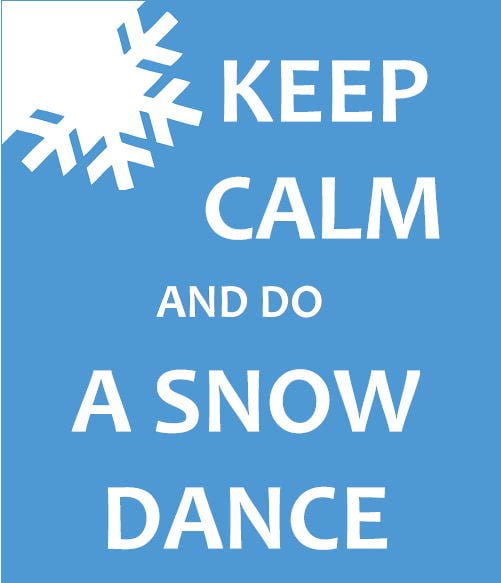 One of our long-time readers emailed me last night saying, “Mike, you guys have always done a fabulous job of keeping us informed about what to expect on the mountains. I know a few years ago when the weather was warm, you guys did a contest for snow dances. Maybe it’s time to think about doing one for this season.”
The video below was the winning video from Tom Curley from back in 2009 when we last needed one!
Isn’t it amazing how much better videos are these days…but that one from five years ago was pretty good.
Believe me, I was thinking about doing that until I got a look at the forecast for this week ahead. I guess we COULD have done one and then claimed that it worked with all the cold air coming in.
Then again, we’re still snow-starved in the region, so maybe we’ll get one going. Stay tuned.
Thus far this season has been a bit of a “Groundhog day-like” theme but instead of waking up every morning to snow, we’ve seen temps in the 40s and 50s with more rain than I want to talk about.
Base depths have been so up and down that any graph charting those would resemble an EKG.
The only thing worse than a 50° afternoon in the winter in the mountains, is a 50° MORNING in the winter in the mountains.
Okay there’s one more “worse thing”. As I was sitting here writing this blog, the Vail Resort alerts that I had signed up for last week to keep me informed about the conditions – JUST texted me that Vail had received YET ANOTHER 4″ of snow last night. Good grief…
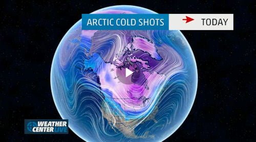
BRING ME SOME OF THAT PURPLE…
Thanks to THE WEATHER CHANNEL for the use of their forecast graphic for this week. Cold begins to filter into the region tonight and the REALLY cold air will take temps down to single digits and even some BELOW ZERO DEGREE temps by Wednesday. Highs are forecasted to be some 15-25° COLDER THAN NORMAL for this mid-week.
We invite our readers to check out THE WEATHER CHANNEL’S forecast video here…
We’ll share Meteorologist Brad Panovich and Herb Stevens forecast videos with you this week as I’m certain they’ll be talking this cold snap!
Our hope is that this cold snap will be a prolonged one such that we can get about enjoying a more typical, cold & snowy period throughout all of January, February and March. You guys with me?
CHECK OUT THE SNOW REPORT FOR ALL OF THE DETAILS AND SLOPE OPENINGS.
THE FORECAST FOR ALL OF THE RESORTS – INDIVIDUALLY…
I had some emails yesterday asking me for specific forecasts for a couple of resorts. The truth is that we tend to group all of the ski areas within the region TOGETHER as if one forecast fits all of them. Our coverage area runs from Wisp Resort in Maryland, through all of West Virginia, Virginia, Tennessee and North Carolina and the truth is the weather and climate within the state of North Carolina alone is so diverse that sometimes a more detailed look is needed. With that in mind, we’ve done that for you guys this morning.
Wolf Ridge Resort – 50° and moderate rain is falling this morning. I’m reporting on Wolf FIRST today, because Rick, Orville and their crew have GOT to be asking themselves what the heck they’ve done to deserve the Groundhog Day load of you-know-what that they’ve been dealt with in terms of weather patterns over the last 2-3 years. Last season’s weather was decent, but even then they had to deal with the fire at the lodge and some less-than-prepared potential buyers who left them with some additional debts. THIS SEASON has just been the pits so far in terms of weather that would allow them to open ANYTHING to attract the crowds that they sorely need.
They had fought their way to SIX trails open but with the rains have had to drop that back to FOUR open trails today.
THANKFULLY HELP IS ON THE WAY…
Lows tonight should dip to 20° or so with some light snow possible. Then they SHOULD be able to make snow on SIX of the next SEVEN nights and they’ll have some around-the-clock ops from sometime tonight through Tuesday…and then they MAY have to turn the snowmakers off on Tuesday but restart everything Tuesday night and KEEP them on until sometime on Saturday.
Those conditions SHOULD allow Wolf to open more terrain than they’ve been able to all season thus far. That should excite fans of Wolf Ridge to get out this week and play.
Ober Gatlinburg – 55° and raining. We’re talking “Ober” second, because as tough as the weather has been thus far for Wolf Ridge…you can “ditto” that and raise them a couple of degrees for the Smoky Mountain ski area. Ober has the most unique snowmaking system in the region in that they can actually make snow at high temps than anywhere else. HOWEVER it makes no sense to make snow and see it melt away with the mild temps they’ve had. They are experiencing heavy rain as of this blog post this morning ;-(
Ober has had to operate with only TWO of nine trails for much of the this season so far. (They HAVE had a few more open a few times…) With only TWO trails open, they’ve also operated with NO chair lift to service those two slopes and only the surface handle tow available.
It’s been a frustrating bit of weather patterns for Ober’s peeps…and while some of the region’s ski resorts will see frigid temps for most ALL of this next week, Ober’s weather looks a bit milder with perhaps FOUR of the next SEVEN nights providing opportunities for snow making. In fact, Ober’s overnight lows may not allow for normal snowmaking ops until Tuesday night when it dips to 27°. Wednesday night’s low is forecasted to dive to 8° (when most of the region will be in the MINUS degree temps. Thursday and Friday should be cold enough for snowmaking as well.
THAT should get some decent slopes open for next weekend.
LET’S NOW SHARE THE RESORTS THAT HAVE HAD IT BETTER…
Snowshoe Mountain – 51° and rain today. Snowshoe looks pretty darn good and all you have to do is click onto ANY of the LIVE webcams to see that for yourself. This winter has been subpar for all resorts in the region, but even so Snowshoe has been able to open and maintain 172 acres of good skiable terrain with 44 trails open.
After the rain clears out today, Snowshoe could see some light snow tonight, Monday and again on Wednesday. More importantly they will see lows in the single digits and teens EVERY night this week ahead and highs in the single digits Wedneday (with light snow), teens on Monday, Thursday and Friday and 20s on Tuesday. With those kind of conditions look for even MORE trails open by next weekend!
I will be at Snowshoe next weekend with friends…so if YOU are planning on being there…email me and we can make some turns.
Winterplace Resort – 49° and light rain. Terry, Tom, Missy and their crew have been able to maintain the largest percentage of their slopes open all of this early season thus far. They still have 24 of 27 slopes open and things will only get better with the forecast for the week ahead.
Ghent, WV (home to Winterplace) should see highs in the 20s most all week and lows in the upper teens and low 20s except for an overnight low of near ZERO on Wednesday. Those temps will allow for around-the-clock snowmaking and we could see Winterplace go to 100% open on all 27 trails this week.
Wintergreen Resort – 51° Wintergreen’s marketing peeps do such a nice job of reporting every morning, that I’ll simple share their morning blog comments:
A BIG snowmaking run is headed our way with around the clock snowmaking temps starting tonight and lasting into next weekend. Look for additional trail openings, deeper base depths, wider trails and both terrain parks open by next weekend. The ski area is going to get A LOT bigger and better this coming week!
Wintergreen’s temps are forecasted to be a notch milder than those in West Virginia and the higher elevations of North Carolina – however they’re still cold enough to make snow with the possible exception of during the day on Monday and Tuesday. They should see single digit temps overnight on Wednesday and teens and low 20s all week.
Canaan Valley Resort – 42° and they’re report and website is reporting that they are making snow. That is a glitch. David Vance DID post, “Old Man winter is on it’s way so let’s spend the time sharpening and waxing those skis and boards,
because some really good riding and sliding is at hand.. see you on the slopes.”
You heard him and he’s correct! Temps should nose down to 15° tonight with some chances of snow tonight, Monday, Tuesday, Wednesday and Friday. According to weather forecasters, there’s a bit of a pocket over that part of West Virginia that could make for colder temps as well with the following forecast for Davis, WV.
Sunday night – 15° and snow possible
Monday – 16° and a chance of snow
Monday night – 10° with flurries
Tuesday – 27° and a chance of snow
Tuesday night – 12°
Wednesday – 11° and a chance of snow
Wednesday night – MINUS 6°
Thursday – sunny and a high of 10°
Thursday night – 7°
Friday – 17° and light flurries
Friday night – 4°
…and the weekend looks sunny with highs in the upper 20s and lows in the teens.
You guys ready to head to Canaan Valley or Timberline???
Timberline Resort – 42° and ditto Canaan’s forecast for the week ahead. Tom Blanzy and his crew were able to ADD a slope opening for today to get to 16 open trails for day sessions today. With the forecast for the week ahead with around-the-clock snowmaking and some light snow as well…look for amazing conditions through the week and into next weekend.
Beech Mountain Resort – 45° – light rain this morning but Beech should recrank the snowmaking system late today as temps rocket down from a high of 54° today to around 19° tonight. Then highs from 18° on Monday, Wednesday and Thursday to around the 20s to perhaps the mid 30s on a couple of afternoons this week. It looks like sunny conditions most all week, which should make for great conditions for skiing and snowboarding. Winterfest at Beech is January 10-11th and it should be very nice conditions and weather for all of the fun, including the Cardboard Box Derby, etc. Kenny Griffin will be talking more about that as we get into next week.
Sugar Mountain Resort – 47.5° and light rain. I was over at Sugar on Saturday around 3pm and you could not see the mountain for the heavy fog and moderate rain that was falling. Those conditions have Sugar reporting a 5″ drop in base to reflect a 20-58″ base on the 12 slopes that they have open. Gunther and his crew will recrank the snowmaking system late today as temps rocket down from a high of 54° today to around 19° tonight. Then highs from 18° on Monday, Wednesday and Thursday to around the 20s to perhaps the mid 30s on a couple of afternoons this week. It looks like sunny conditions most all week, which should make for great conditions for skiing and snowboarding.
Omni Homestead Resort – 60° and rain this morning. The Homestead Resort is yet another ski area in our region that has had to fight the weather moreso than most of the resorts in the region. It is some 20-25° milder this morning than 24 hours earlier.
Lynn Swann emailed me this morning that they will operate today with the same 2 slopes that they’ve had open thus far this season. She also noted that snow making will resume tomorrow and she’s correct…but THEY MIGHT be able to make snow TONIGHT as lows are forecasted to drop to 24° Sunday night and then the high Monday should be around 27°. We’re seeing lows cold enough to make snow ALL SEVEN nights this week ahead with the lowest temp being a 1° Wednesday morning with some chances of light snow as well. Otherwise it should be pretty skies all week with highs in the teens and 20s. Things are set up well for a very nice weekend ahead.
Massanutten Resort – 48° this morning with light rain. One look at their webcams will tell you that the snow has held up well there and snowmaking temps and nice weather is on the way! Steve, Kenny and their crew should be able to make snow tonight and every night this week with lows in the single digits Wednesday night and some around-the-clock moments this week as well. Massanutten MAY be 100% open by next weekend.
Bryce Resort – 52° this morning with light rain and fog. They are forecasted to reach 62° freaking degrees today! It should be a nice week ahead for the Basye, Virginia resort. Highs should be in the 20s to near 40° for most of the week and they should see lows cold enough to make snow on SIX of the next SEVEN nights. They should get around-the-clock snowmaking ops from Tuesday night into sometime on Saturday. That should make for awesome conditions at Bryce, Bryce, baby. (I couldn’t help myself.)
Appalachian Ski Mountain – 49° – light rain this morning. The forecast for this week at App is for sunny skies and plenty of cold to make snow every night for the next SEVEN nights! Lows should dip to MINUS 1-3° on Wednesday night, but there’s teens and low 20s in the forecast for every night this next week.
Cataloochee Ski Area – 47.5° and they dropped nearly 8″ of base to report 25-28″ of base and they also dropped 2 trails to now show 9 of 17 slopes open for DAY SESSIONS only on Sunday. Light to heavy rain has been falling but there’s good news for the Maggie Valley ski area as well as they SHOULD be able to make snow on AT LEAST five of the next seven nights and around-the-clock snowmaking opportunities from Tuesday night through Saturday morning.
Wisp Resort – 52° – forecasted to drop to 19° with snow tonight and then a HIGH of 19° on Monday. Lows down to MINUS 3° Wednesday night with lows from NOW through at least the weekend in the single digits and teens and highs in the teens to mid 20s by next Saturday.
Sapphire Valley Ski Area – 50° and light to heavy rain is being reported in the area. TALK ABOUT GROUNDHOG DAY MINUS THE SNOW! Sapphire is still closed and awaiting cold air. They’ve only be able to make snow and be open for a few days yet this season. Colder air IS on the way, but it may be borderline over in the Southwestern portion of the state. Right NOW it looks like MAYBE some snowmaking late tonight or overnight and then Tuesday night with lows around 26°. It WILL BE a low of 4° on Wednesday night and the around-the-clock snowmaking ops from then until sometime on Friday. That should get them open for next weekend.
Email me your thoughts and reactions at: [email protected]
FOLLOW US on Twitter for up-to-date news (like when it SNOWS) and for the best chances to WIN our FREE LIFT PASSES, VACATIONS, FREES SKIS, FREE SNOWBOARD and more! We’re giving a LOT away this season and all you have to do is FOLLOW US ON TWITTER, Subscribe to our SkiMail list at the bottom of every page of the website OR Join Us on the SnoForum
They’re ALL FREE to Join, Subscribe or Follow Us and we promise to keep you well-informed. Share our website with your friends. We’d appreciate it a lot.