Check the snow report page for all of the resort slope conditions at a glance. See: https://www.skisoutheast.com/skireports.php.
Wow, what a weekend it was! It is crazy how much different things look this morning compared to a week ago at this time. Up to thirteen inches of of natural snow blanketed the ski areas in the region over the last 72 hours. It really is amazing how this one weekend has completely transformed the resorts.
Mike went over snowfall numbers over the weekend, but I figured I would give the final tallies for this event, so here you go. These numbers are for the entire weekend.
Appalachian Ski Mountain – 1”
Beech Mountain Resort – 6”
Cataloochee – 2”
Sapphire Valley – Trace
Sugar Mountain – 5”
Wolf Ridge – 2.5”
Bryce Resort – 1”
Massanutten – 0”
The Homestead – 1”
Wintergreen – 0”
Canaan Valley/Timberline – 11.8”
Snowshoe Mountain – 10”
Winterplace – 6”
Wisp – 13”
Ober Gatlinburg – 5”
It comes as no surprise that the West Virginia and Maryland ski areas saw the most snow. I’m hoping Ed Schneider of Snowshoe will have a video edit sometime soon showing how conditions were yesterday and how they are today. Powder conditions are in effect for the resorts up that way.
One thing I like to do is look at the snow to liquid equivalent ratio to see just how good the powder is. Based on www.cananweather4t.com, 11.8” of snow fell at Canaan Valley and Timberline over the weekend. The liquid equivalent was measured at .83”, so that means the ratio was approximately 14 to 1. The average ratio is 10 to 1 so that is some pretty good powder. I’m sure a lot of people visited the white room yesterday.
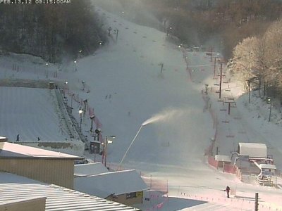
Even though Ober didn’t see the most snow of any resort, I’d have to say they are the big winners. They received 5” and the snow and cold temperatures have allowed for the most dramatic change in conditions of any ski area in the region. Their base depth has more than doubled and the camera this morning looks fantastic. Things were getting a little rough out there last week but that is definitely not the case right now. .jpg)
<<< Ober Gatlinburg looks fantastic this morning! It’s crazy how much better things look than a week ago at this time.
The other big story this weekend was the wind and absolutely frigid temperatures. Our Sugar Mountain station recorded a wind gust of 39 mph on Saturday. The official NWS station in Boone actually recorded a wind gust of 56 mph. 56 mph! The wind combined with the cold air to make for some pretty dangerous conditions. The Sugar station recorded a wind chill of -23.4 degrees at one point on Saturday night. In fact, the wind chill was in the negatives for over 24 hours straight at one point before finally going back above zero yesterday afternoon.
Temperatures this morning across the region are still very cold, but they are a good 10-15 degrees warmer than 24 hours ago. Just so you guys know, we added a new weather station over the weekend at Winterplace. You can now head on over to WinterplaceWeather.com to check out real-time weather conditions at the West Virginia resort. You can now get up to the date temperatures, wind readings, and other weather data. I’m pretty stoked about it and I’m hoping we can convince all of the ski areas to get on board.
One thing I’d like to address which Mike already did in his post last night is that I’ve seen a lot of people complaining about the fact that the resorts had the snow guns on all weekend. The windy, frigid conditions combined with snowmaking made for some pretty brutal conditions on Saturday. I understand it can suck to be in those conditions. I’ve been in them many of times myself. However, with the crummy weather we’ve had this winter, it’s pretty much a necessity that the resorts make snow whenever they can for as long as they can. It really is a pet peeve of mine when I see people complaining about them. You have to be prepared for that here in the Southeast and mid-Atlantic as we are lucky to be able to ski and snowboard for as long as we do each year simply because of the aggressive snowmaking. Always make sure to check the weather forecasts and look at the cams before heading out and you will never be caught off guard. Just my two cents.
SNOWSHOE SUMMIT
Alright, I know I haven’t mentioned it in a few weeks, but don’t forget about the Ski Southeast Summit at Snowshoe Mountain on March 2nd, 3rd, and 4th. Head on over to the messageboard and read more about it by CLICKING HERE. I’m hoping I will have all the details finalized today and I can tell you more tomorrow. Mark Glickmann, call me if you see this!
Enjoy your Monday people. It’s going to be a nice one and if you are on the slopes, I am jealous. I have to wait until tonight to ride and I’m pretty pumped for it. It’s going to be a bluebird day with great snow conditions. What else can you ask for?.jpg)
<<< The sun is already shining at Beech this morning. It’s going to be a great day at all of the ski areas in the region today. I’m pumped to go riding tonight.
Email me your comments, thoughts, photos, vids or anything else you like at [email protected]