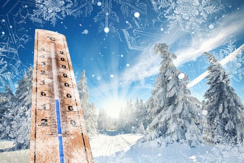
This particular FirsTrax update is LONG and it is for all of you snow enthusiasts who just need ANYTHING to keep those snow-loving, skiing and snowboarding flames flickering until Winter f-i-n-a-l-l-y arrives. So read and enjoy – hopefully.
 This IS our 20th Anniversary here on SkiSoutheast.com and we’ve always shared all of the preseason, long-range weather forecasts for each winter season. However, we’ve never come out with our own. The truth is that we have some awesome resources in Meteorologists Brad Panovich and Kenny Griffin – so why do one, right?
Well I thought it would be interesting to try something probably unscientific as heck and see how close I can come to accurately predicting the winter weather. I mean I can’t be much further off than some of the pros have been over the years. I was reading Dr. Ray Russell’s Fearless Forecast for this season and he’s pretty darn cool about grading his previous season’s forecast and he admits to missing his Beech Mountain forecast by 46″ last season. That forecast was two inches short of being a whopping FOUR FEET off the mark. Just for the record, Ray did a nice job of forecasting the 2013-2014 winter.
SO WHY START DOING A WINTER FORECAST OF OUR OWN?
We’ll still look to get Brad Panovich to provide us with his, more expert appraisal of what to expect for this winter. However, I was thinking about the fact that we started this website twenty years ago and that in that time we have documented seemingly every flake of snow that has landed at a ski area that we cover. Seems to me now that weather gurus are better able to understand the effects that El Niños have on our weather…that I should be able to look back at years when the El Niño was very similar and then simply look at how much snow fell at each ski area and “presto change-o” we should have an inkling of what we could expect in terms of snowfall.
On October 15th, 2015 forecasters at NOAA’s Climate Prediction Center issued the U.S. Winter Outlook that is AGAIN favoring cooler and wetter weather in southern tier states with above-average temperatures most likely in the West and across the northern tier. This year’s El Niño, among the strongest on record, is expected to influence weather and climate patterns this winter by impacting the position of the Pacific jet stream.
“A strong El Niño is in place and should exert a strong influence over our weather this winter,” said Mike Halpert, deputy director, NOAA’s Climate Prediction Center. “While temperature and precipitation impacts associated with El Niño are favored, El Niño is not the only player. Cold-air outbreaks and snow storms will likely occur at times this winter.”
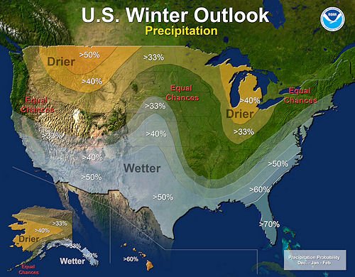 NOAA’s latest mapping shows that much of our ski area coverage should get from 33% to 44% more precip than normal. The 40% swath seems to be over portions of Virginia and North Carolina – while 33% or so is over much of the Virginia ski areas.
Their mapping seems to suggest “equal chances” of slightly more or slightly less precipitation than normal for areas around the West Virginia and Maryland ski resorts. Knowing how much snow that Maryland and West Virginia can wring out of moisture – I think it’s safe to stay in that 33-44% range.
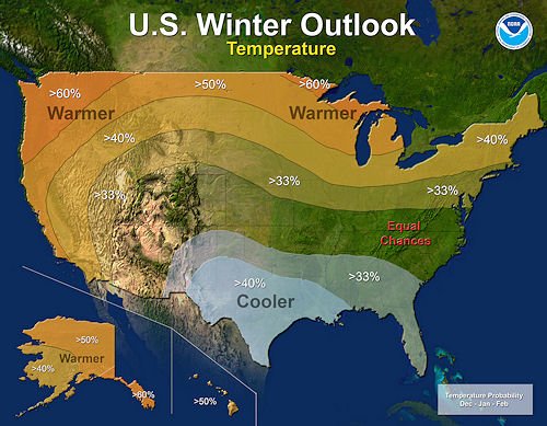 In terms if temps – the latest NOAA predictive mapping shows “equal chances” of either slightly cooler or slightly warmer temps than usual…again with “slightly warmer” across the northern tier of our ski area coverage. Again, we’re not buying it because that mapping is a broad stroke instead of considering the highest elevations, like Snowshoe’s 4848′.
…and we’re repeat (for emphasis) NOAA’s statement of, “This year’s El Niño, being among the strongest on record.”
THIS BABY IS TOO BIG TO FAIL!%!%!
We can’t read or look at any weather website these days without reading some foreboding titling as they seem to name each storm and weather phenomenon as never before. It’s like blockbuster movies these days as weather “experts” are forecasting life-changing weather at every turn…and this winter’s El Niño is no different.
Bill Patzert, a climatologist at Nasa’s Jet Propulsion Laboratory, posted on October 14th:
“This winter will not be normal. Whether El Niño gets slightly stronger or a little weaker is not statistically significant now – This baby is too big to fail.”
Other scary weather headlines related to this year’s El Niño are:
“2015 El Niño Could Be One of the Strongest Since the 1950s…”
“Heavy Snow Warning: Worst El Niño in recorded HISTORY means UK faces winter WHITE-OUT.”
“El Niño Creates More Favorable Conditions for Winter Tornadoes in Florida.”
“Hunting the GODZILLA El Niño.”
I don’t know about you guys but I’m envisioning shark-nadoes.
Okay, enough with the over-the-top drama. What we can share is that all weather gurus seem to be pointing at this year’s El Niño as being the strongest ever. Stronger than the El Niños of 1982-1983 and 1997-1998. So at least in theory we can point to those years as some kind of barometer of what we might expect for this season’s snowfall totals.
So JUST HOW MUCH SNOW should we Expect This Winter?!?!
I know that my buddy Joe Stevens will roll his eyes the moment that he gets past the first sentence of this article. He – along with me and most of the more rational thinking weather enthusiasts – thinks that forecasting the weather past about four days is like trying to predict the score of a college football game two months in advance.
I mean there IS some science to knowing what football players might be available to you. But two weeks from now you could have three key players get injured and that would screw up the entire process of predicting an outcome so far in advance. It’s tough enough predicting how things can go for THIS weekend’s games.
So it is with weather prognosticating…on steroids.
So why do we do it?
We’ve all heard one of our friends share things like, “Hey, did you know it’s suppose to rain this weekend.” Then we respond with the traditional, “Yea, like they know what the weather’s going to do TOMORROW. The forecast will change by this weekend.”
…and THEN we seem to grasp onto a cold, snowy, winter forecast.
…or at least I do – and from early lodging numbers at various destination resorts around the region – MANY OF YOU DO AS WELL!
I was speaking with one of our resort partners the other day and they are almost at FULL CAPACITY for the Christmas-to-New-Year week.
Seems that people are listening to the long-range forecasters out there who are predicting a cold, snowy winter. The truth is – there IS more science to it than ever before. Meteorologists have been more accurate about forecasting trends and they also have so much more material to work with these days. They can now accurately measure the strength of El Ninos and other factors and compare them to dates in the past where the contributing factors were similar. Similar factors produce similar results.
Everything that we’re reading and viewing is predicting a somewhat COLDER winter than normal for the Southeast and mid-Atlantic AND wetter than normal. Some prognosticators are forecasting 150% of normal snowfall for our area. I read where Aspen may see 150-170% of normal snows for November and 200% of normal snowfall for December!
JOE BASTARDI SAYS GET YOUR SNOW SHOVELS READY
On September 16th, we published a story that shared WeatherBell’s winter forecast that states that we should be prepared for 200% of normal. See that story here: WeatherBELL Winter Forecast
That update was shared at the end of August and upgraded from their previous forecast of 150% of normal. The upgrade came because of a stronger than usual El Niño.
We’ve read other long range forecasts that are predicting 150% of normal snowfall and -1° to -3° colder than normal temps.
Most recently I saw where Dr. Ray Russell joined in and his forecast for the mountains of North Carolina seems to be in the 133% of normal range.
SO JUST WHAT DOES THAT MEAN FOR THE SKI AREAS OF THE SOUTHEAST AND MID ATLANTIC?
First, I have to brag a bit.
SkiSoutheast.com is THE ONLY resource (I challenge you to go find another source) that has kept up with every inch of snowfall that has fallen across every ski resort in the region for the past nineteen seasons. (This is our 20th season.) Because of that we’ve documented annual snowfall for each season.
Back in 2004 we created a newer website (new for back then) that was database driven and since that time we’ve been able to go back and look at what each and every day was like. We can go back and see article content that was published for each and every day…including snowfall reports.
We can go back (with some good digging) and tell you exactly what a particular day was like at every ski resort in the region.
Data is powerful. It can really come in handy when we start jumping on the 150-200% snowfall bandwagon. However in an effort to be at least SOMEWHAT rational with our forecast/prediction I need share how our numbers might be a little different than most.
Let me explain.
If you go out on any major ski website in the United States you can find a “NUMBER” that each resort claims as it’s AVERAGE SNOWFALL per season. Bear in mind that these numbers have probably NOT been “revisited” since each ski area originally opened. I know that I’ve been covering the industry regionally for twenty years now and I’ve never seen them adjusted.
 But are they accurate? Some weather gurus will tell you that they have accurate snowfall data that dates back 56 years. Well I can tell you that in 1959 “Harvey” or whoever else was recording snowfall data didn’t keep up with things accurately if his back was out or if he just didn’t feel like it. That’s the way things were done back then. Sure, some pocket-protector-wearing pencil pusher probably kept great records but he sure didn’t do it for ski areas that were not even around 56 years ago.
Even in recent years you couldn’t get accurate temperatures for Seven Devils, North Carolina; Hot Springs, Virginia; McGaheysville, Virginia or Blowing Rock, N.C. (all are home to ski areas in the region.)
I dare you to go find out how much snow fell atop Seven Devils, North Carolina (home to the old Hawksnest ski resort) in 1990. The truth is that there are NO official readings for the Blizzard of ’93 at MANY of the locations where our region’s ski resorts are located.
Hell, just a couple of years ago if you looked at Weather.com to view the temperature for Beech Mountain, you’d actually be looking at the temperature that was captured at Boone, North Carolina. It isn’t a WHOLE lot better now.
CAN WE JUST GET TO THE OFFICIAL SKISOUTHEAST.COM 2015-2016 WINTER SNOW FORECAST???
We’ll get there. However to do so, we have to know WHAT “AVERAGE” is. We’ll leave it to you guys to go search the internet (or this website) to see what each ski area SAYS is their average annual snowfall. (On our website, all you have to do is click on “RESORTS” (pick one) and then click the “MOUNTAIN STATS” link.)
Of course you can also pick up most any ski resort brochure to see that marketing number as well.
However for the purposes of our prognosticating effort, we compiled the numbers for the last (11) years and we’ve presented them below.
AVERAGES FOR SNOWFALL AT EACH SOUTHEASTERN SKI RESORT SINCE 2004:
(Data shared from the last (11) seasons. Ranked by Average Snowfall…highest to lowest.)
| Ski Area | Snowfall Total | AVG | High | Year | Low | Year |
| Canaan Valley Resort | 1805.1″ | 164.1″ | 250.8″ | 09 /’10 | 113″ | 04/’05 |
| Timberline Resort | 1805.6″ | 164.1″ | 250.8″ | 09 /’10 | 112″ | 04/’05 |
| Snowshoe Mountain Resort | 1797.4″ | 163.4″ | 229″ | 09 /’10 | 112″ | 11/’12 |
| Wisp Resort | 1468.6″ | 133.5″ | 226″ | 09 /’10 | 77.1″ | 11/’12 |
| Winterplace Resort | 984″ | 89.5″ | 161″ | 09 /’10 | 53.5″ | ’11/’12 |
| Beech Mountain Resort | 867.0″ | 78.8″ | 130.5″ | 10/’11 | 38″ | 07 /’08 |
| Sugar Mountain Resort | 801.3″ | 72.8″ | 118″ | 09 /’10 | 35″ | 07 /’08 |
| Wolf Ridge Resort | 511.5″ | 46.5″ | 100″ | 09 /’10 | 13.5″ | 11/’12 |
| Cataloochee Ski Area | 471.4″ | 42.9″ | 66.7″ | 10/’11 | 12.7″ | 11/’12 |
| Appalachian Ski Mtn | 432.1″ | 39.2″ | 71.8″ | 09 /’10 | 17″ | 07 /’08 |
| Massanutten Resort | 323 | 29.4″ | 70″ | 09 /’10 | 11″ | 07 /’08 |
| Ober Gatlinburg | 322.3″ | 29.3″ | 45″ | 09/’10 | 9″ | 11/’12 |
| Wintergreen Resort | 321.5 | 29.2″ | 42.2″ | 09 /’10 | 7.6″ | 07 /’08 |
| Bryce Resort | 312.6″ | 28.4″ | 75.8″ | 13 /’14 | 5″ | 11/’12 |
| The Omni Homestead | 211.4″ | 26.4″ | 54″ | 09 /’10 | 6″ | ’07 /’08 |
| Sapphire Valley Ski Area | 113.0″ | 12.6″ | 32.9″ | 09 /’10 | 2.5″ | 11/’12 |
Note that while many ski areas are averaging CLOSE to their reported snowfall numbers, only Wisp Resort and Cataloochee are averaging MORE than they report as an average.
Now armed with what the AVERAGE snowfall totals are for each ski area over the last (11) seasons AND using all of the predictions models out there, we can come to our official forecast for the 2015-2016 Winter Forecast.
| Ski Area | 15-’16 Prediction |
| Canaan Valley Resort | 230″ |
| Timberline Resort | 230″ |
| Snowshoe Mountain Resort | 235″ |
| Wisp Resort | 180″ |
| Winterplace Resort | 140″ |
| Beech Mountain Resort | 125″ |
| Sugar Mountain Resort | 118″ |
| Wolf Ridge Resort | 85″ |
| Cataloochee Ski Area | 74″ |
| Appalachian Ski Mtn | 70″ |
| Massanutten Resort | 62″ |
| Ober Gatlinburg | 68″ |
| Wintergreen Resort | 50″ |
| Bryce Resort | 57″ |
| The Omni Homestead | 54″ |
| Sapphire Valley Ski Area | 30″ |
So there you have it. We took the actual average snowfalls that we’ve monitored over the last (11) seasons, multiplied them by 133-144% and adjusted them to compare favorably with some of the largest snowfall seasons on record at each resort. Then we considered the NOAA chances for colder, warmer, wetter, drier variables and finally added in some pixie dust to come up with this prediction.
You’ve now spent probably 20 minutes reading through this mindless babble to read that, “NO, we’re not serious. Or ARE we?”
Whatever. It DOES appear that we’re in for a great ski and snowboarding season and the truth is – as long as those snowmakers can do their thing…we’re gonna have a great time on the slopes. Here’s just hoping that we get more than we deserve in terms of some awesome powder days and that sharks are not included in any of those Florida tornadoes.
Until next time…email me at [email protected]