
Nestled in the beautiful mountains of Western North Carolina and conveniently located just 5 miles off I-26, Hatley Pointe is the closest resort to Asheville and Northeast Tennessee for winter time fun for all ages.
Hatley Pointe peaks at an elevation of 4,700 feet, and sits in the shadow of Big Bald Mountain. Whether you are a beginner or expert, long-time regular or first-time visitor, you are certain to find exactly what you are looking for at Hatley Pointe.
New Ownership Bringing Big Things in 2023-24 Season
Deborah Hatley and her husband David purchased the resort formerly known as Wolf Ridge in March of 2023, and started an ambitious campaign project to revitalize the resort under a new name – Hatley Pointe.
The resort is going to feature new technology, fewer lines, shorter wait times, a new lodge, upgraded snowmaking equipment, new dining options and more. The Hatley’s are bringing a new vision to one of the hidden gems in the Southeast.
The Easiest Access
Hatley Pointe is North Carolina’s most accessible ski slope. You won’t find miles and miles of two lane roads and harrowing curves—the resort is located just 5 miles from I-26 (exit 3) and just 30 minutes from Asheville, North Carolina.
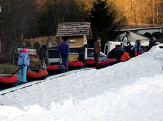
The resort offers great terrain for beginners to advanced skiers and snowboarders, and those who enjoy Mars Hill Snow Tubing.
Lodging Profile
There are rental cabins in and around the Mars Hill Ski Resort. In addition, there are several hotels that offer discounts for skiers.
Featured Area Lodging
 We are proud to promote the following lodging choices that are on or very close to Hatley Pointe:
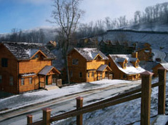
Scenic Wolf Resort is conveniently located near the top of Hatley Pointe. All cabins are located close to the ski slopes, and these beautifully designed rustic log homes include picturesque mountain views from wraparound decks, full kitchens, large living spaces with fireplaces and three or four bedrooms. Swim in the sky-high, glass-enclosed, heated pool year-round.
They have added 8 new furnished townhomes that will sleep up to 16 people overlooking the Breakaway ski slope. These units are great for groups and large family gatherings!
For more information or to make a reservation, please contact Scenic Wolf Resort at 877-828-9653 or www.scenicwolfresort.com.
Travel to the Resort
Asheville Regional Airport
708 Airport Rd #1
Fletcher, NC 28732
(828) 684-2226
Greenville-Spartanburg Intl Airport
2000 GSP Dr
Green, NC 29651
(864) 848-6280