After nearly 3" of rain fell on Sunday into Monday, we’ve now received up to 3" of snow across the ski areas of the Southeast and Mid Atlantic. If you look up "volatile weather" in the dictionary it might reference this winter’s weather thus far. It’s been interesting to say the least.
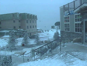 <AM LIVE SHOT at the Top of the World at Snowshoe Mountain confirms windblown snow!
Snowshoe Mountain is reporting 3" of snow and we spoke with two clients up there that confirm that perhaps MORE than 3" of snow has fallen thus far and it’s still snowing.
One report stated, "It has been incredibly windy so you won’t see a blanket of new snow but there’s been at least 3-4" and more is falling right now."
YES…we have a new camera partner in Elk River Ski & Snowboard Shop that is located within the Soaring Eagle building and they’ve powered up a LIVE camera that will be featured on www.HighCountryWebCams.com beginning sometime today. That camera can be panned, tilted and zoomed around to show some awesome sunsets that Snowshoe’s 4848′ elevations are famous for. We can also zoom in to show the exit of the Soaring Eagle lift. Owner Gil Willis plans to partner up on another camera off the back of the shop to provide a better angle from that side of the mountain. It’s always great to do some people watching and this camera will help to show visitors the weather conditions atop the resort. Maybe we’ll get that camera updating fast enough to show off some of their 180" + snows! Visit Elk River Ski & Snowboarding at www.RideSnowshoe.com
Snow lovers stay tuned!
It is now 10:34am as I’ve just finished speaking with several of our contacts around the region to get insight as to how much snow has fallen and where. One cool thing that I noticed as we toured the area’s websites is that several of the ski resorts which had not adjusted base depths during the last 12 days of January thaw – finally did. Hey, it’s better late than never. We catch too much grief from the regional press for what is perceived to be "bogus base depth reporting" so it would be nice to see all resorts make an improved effort to stay on top of those numbers. Most of our region’s resorts do a GREAT job of it, but it only takes two or three not reporting to spoil the perception of integrity.
The cool thing is that now ALL BUT ONE of the resorts in the region have made some adjustments recently so as Martha Stewart says, "That’s a good thing."
So now that the temps have nosedived we’ll see base depths going up! All of the resorts look GREAT this morning and skiing and snowboarding wherever you choose to ride will be sweet today.
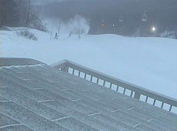 <Top of Big Red this AM. A dusting to an inch of snow fell and snowmaking is happening!
I took some time to tour the area’s live webcams this morning and spent a lot of time up top at Sugar watching them groom Big Red and also watching the snow gun that they have positioned in the middle of the trail blasting the top with snow. There’s no question that Gunther’s crew can work and groom the snow as good as any resort in the country and from the look of Big Red this morning they will have some sweet corduroy coverage.
There’s also no doubt that any small areas of thin coverage and/or bare spots are now history. There was already a ton of snow on all of the mountains, so it didn’t take much to make those little blemishes in the snow disappear!
Our Chief Meteorologist Brad Panovich provides a new Skier’s Forecast video this morning. Brad was busy late this past weekend and Monday detailing coverage of the flooding rains and was delayed getting his latest update to us but he’s got it this morning.
The summary is that cold and snow has returned with a vengence after twelve straight days of milder-than-desired temperatures and way too much in the way of under-developed snow. Brad shares that it is going to get progressively colder as the week goes forward and we have the potential of a major winter storm in the forecast!
This morning we are seeing northwest flow snows that have already dropped anywhere from an inch of snow at Beech and Sugar Mountain to 2" at Canaan, Timberline, Wisp and Winterplace to 3" of new snow at Snowshoe.
Brad says that we should see some snow through Wednesday at many locations. We’ll get a little "break" on Wednesday and then the possibility of a huge storm on Thursday into Friday. Brad thinks that this next system will begin as some rain in some locations into the North Carolina mountains and then turn over to some significant snow that may develop by Friday and into the upcoming weekend. Brad stated the words "huge storm" numerous times in his Skier’s Forecast video.
We’re already seeing some breaks in the clouds here in the Western North Carolina mountains this morning but Brad still seems to think that we’ll see a bit more snow with 4-6" of snow accummulating into the West Virginia mountains and 1-4" into the Virginia and North Carolina mountains through Wednesday at 9pm. Most of that may already have taken place this morning.
Now for the BIG STORM POTENTIAL…  < Brad’s weather forecast map for this week shows snow! Maybe BIG SNOW!
Brad shared that the way things are shaping up as of this morning it looks like the next storm track will come in the same kind of setup that we had back in mid December where HUGE snows fell across the region.
Brad’s thinking that the storm track will stay slightly north and brings heavy snows from Wisp down into the North Carolina resort areas. If that storm tracks further south then he thinks that the heavier snows may stay further south into the NC mountains. Right now he’s favoring the slightly northward tracking models.
Either way we should see some significant snowfall Friday and into the weekend.
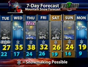 …and we should see very cold temperatures for the snowmakers to do their thing! It looks like most ski areas will be able to make snow all day today as highs are expected to stay sub freezing. Lows tonight should be in the teens. Wednesday and Thursday look nice with highs in the 30s to near 40° at many locations but dip back into the teens and low 20s each night. Then Friday and the entire weekend is going to be FRIGID with snow! Computer models are in agreement at this time for a significant snowstorm in NW NC and SW VA…into West Virginia and Wisp!
STAY TUNED and if you’re heading to the mountains this weekend, pack layers and make sure your 4WD is in good shape! Buy your chains off the mountain as most places that typically carry them are out of a lot of sizes.
A COCORAHS KIND OF DAY!!
We’ve had natural snow on the ground for more than a month and a half now and with more snow falling you’re going to enjoy your trip to the mountains this week and weekend! Anytime we get natural snow these days it takes me about an hour longer to visit all of the COCORAHS reporting stations and official stations like David Lesher’s that provide accurate snow measuring. That the best way we know to be able to update our 24, 48 and 72 hour snowfall totals that we share on the front page of the site. Obviously looking at the live webcams helps because we can sit here in our offices and pan, tilt and zoom into several locations close to the cameras and get a bird’s eye view of how much snow is where.
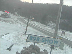 <Live shot this AM at the foot of Sugar shows a nice dusting to one inch of new snow.
With that in mind, we heard from John Huffman up at Fred’s General Mercantile on Beech Mountain at 7:15am this morning. He reported about an inch of snow on Beech Mountain. That jives with Gil Adams’ official station reporting .8" of snow this morning. John was playing "strong politician" this morning when he commented on the air this morning via a local radio call in that he saw where Gunther at Sugar was reporting 2" of snow this morning. He said, "You know this snow came in bands and I don’t know – maybe there was a band of snow that JUST HIT THEM ’cause I see he’s saying they got 2".
Tom Brays is in a condo at The Reserve atop Sugar Mountain and he reported in with his official snow measuring of – you guessed it – .8" of snow. There wasn’t a ton of wind last night but there are some drifting areas where you can find about 2" of snow to ball up into a snow ball, but most of the snows atop and bottom of Beech and Sugar are in the dusting to 1" variety so if you’re headed up that way look for an inch of snow. You won’t find a 2" blanket of snow – just yet. Later in the week – WE HOPE SO!!!
By the way, this .8" of snow brings Beech Mountain to 25" of snow since January 1st and a little over 51" on the season. It has been a good one to date! …and more is on the way!
Let’s go ahead and do a tour today and show a reporting of natural snowfall and temps this morning. Check the SNOW REPORT for all of the other details.
Snowshoe Mountain – 17° – 3" of new snow – Snowshoe has 57 trails open and they are making snow on Cupp today. Tubing, snowmobiling and all is open. Snowshoe has seen 57" of snow since January 1st and 106" on the season!
Note: We reported on Monday that Snowshoe had some flooding after a lot of Sunday night rains. The official COCORAHS report up there showed that 2.83" of rain fell. This has definately been a crazy winter. Now snow is falling and lots of it! Make plans to head to Snowshoe for some great conditions!
Canaan Valley Resort – 21° – 2.1" of new snow and a reported 6" of natural snow base still on the ground. Canaan is reporting snow falling right now with an additional 2" expected tonight. They are reporting a base of 24-48" of snow and 36 trails open for DAYS SESSIONS only today. Canaan has seen 57.6" of snow since January 1st and 117" on the season!
Timberline Resort – 21° – 2.1" of new snow! They have 36 trails open for day sessions and the are not reporting any snowmaking going on. They do have 17 km of cross country skiing terrain open with up to 6" of snow coverage. They they upped their base by 2" overnight. Timberline has seen 57.6" of snow since January 1st and 117" on the season!
Winterplace Resort – 24° – 2" of new snow. They are 100% open with all 28 trails and snow tubing as well. Winterplace is also open for night sessions as well. Winterplace has received 75" of snow this season!
Massanutten Resort – 28° – No report of new snow via their website nor COCORAHS – They are not reporting snowmaking as yet either but that will kick in tonight. They are neverless in great shape with at least 36" of snow base (dropped 4" overnight) and all 14 trails and 8 lanes of tubing open in very nice groomed shape. Mass has seen 24.4" of snow thus far this season.
Bryce Resort – 35° – No new snow – They were at 54° yesterday morning! That’s a change! Bryce must have read our latest reports because they finally dropped their base depth by 6" after no changes in the prior 12 days. They have plenty of snow though and snowmaking temps will hit later tonight and they will make snow. They are 100% open with night skiing and tubing as well. Bryce has seen 28" of snow thus far this season.
The Homestead – 25° – Reporting 1/2" of new snow and it is snowing this morning – They are not making snow but open with all 9 trails for day sessions. Snowmobing and ice skating are open. The Homestead dropped their base by 2" overnight. They’ve seen 23.5" of snow on the season.
Wintergreen Resort – 26° – No new snow – They reopened 10 trails that were closed temporarily on Monday. They are offering 18 of 26 trails for today and night sessions as well. Tubing is open but their terrain parks are closed for snowmaking. Even though snowmaking ops returned overnight Wintergreen is not reporting any at this time. They’ve seen 38" of snow on the season with literally 30" of that happening in one storm.
Wisp Resort – 20° – 2" of new snow! – They dropped their base depth by 2" and dropped a couple of trails from those that were open on Monday to focus on snowmaking. They do have 26 of 32 trails open for day & night sessions as well as tubing and their very cool mountain coaster and ice skating! Cross country skiers should know that Wisp has 40 km of terrain open for Nordic skiing with a base of 4-6" of natural snow! Wisp has seen 87.5" of snow this season and 44" since January 1st!
Ober Gatlinburg – 25° – TRACE of new snow – Ober is 100% open with all 8 trails and snow tubing as well as their Olympic sized ice skating rink that is indoors and includes some great shops. Ober has seen 21" of snow on the season.
Appalachian Ski Mountain – 21° – About 1/2 inch of snow and they made snow and added 2" to the base overnight. (We’re on the way back up!) App is 100% open with ice skating and all terrain parks operating! Groomed conditions! App has seen 40" of snow thus far this season.
Beech Mountain Resort – 25° – .8" new snow – Beech has closed the Oz Run and Upper Southern Star to focus snowmaking ops on them. They are open today and tonight with 12 of 14 trails, their terrain park on the Powder Bowl and of course Robbins Run, White Lightning and their other popular trails. Tubing is not open today. Beech has received 51.5" of snow so far this season.
Cataloochee Ski Area – 19° – About a 1/2 inch of snow and they are making snow and added 3" to their base report. They are 100% open with all 16 trails for day and night sessions. No tubing until later in the week. They’ve seen 35.4" of snow thus far this season!
Sugar Mountain – 18° – .8" new snow – Sugar is 100% open with manmade powder and groomed conditions on all 20 trails. They have their tubing park closed for today for dedicated snowmaking. Sugar has seen 47.8" of snow on the season to date and about 25" of snow since January 1st.
Wolf Ridge Resort – 18° – 1" of new snow according the COCORAHS reporter there – They made snow and have 15 of 20 trails open. Tubing and Terrain Park is open as well. Wolf is reporting "several" inches of snow on their website and 2" on another reporting service. The COCORAHS report jives with the Wolf Laurel POA website which is reporting "…all roads are lightly snow covered from last evening." They’ve seen 39.2" of snow on the season.
Sapphire Valley – 23° – No new snow according to the Transylvania County COCORAHS reporters. – Despite reports to the contrary on some regional and national reporting services, Sapphire Valley is NOT OPEN TODAY as they do not operate Tuesday through Thursdays. They will reopen Friday at noon. They’ve seen 9" of snowfall to date.
Hawksnest’s tubing park is CLOSED TUESDAY. They are making snow and will reopen on Wednesday.
We’re on day 60 and there are 77 more days of opportunities to enjoy the snow for the 2009-2010 ski and snowboarding season!
That’s it for today. Check out the Snow Report at https://www.skisoutheast.com/skireports.php and please send us your favorite ski photos, ski videos, trip reports and comments to [email protected]
SSAA: 1 for 60/several/self 58/60