Happy New Year everyone! Welcome to 2012. It’s always weird to say or write/type the new year’s date for the first time. I’m still getting used to seeing 2012 on the taskbar of my computer screen. Hopefully, all of you had a fun and safe New Year’s Eve. I know I had a pretty good time and I won’t lie, I am still recovering this morning as I type this. I definitely had to hit the snooze button on my alarm a couple times and I will probably be going to sleep as soon as I get done writing. I blame the Jager and Southern Tier for that.
The first day of the new year is going to look and feel much like the month of December. It’s going to be fairly mild out there and there might be a little bit of underdeveloped snow, but things will change quickly later today as a cold front moves through the region. I’ve been talking about it the past few days and now it’s almost here. Monday, Tuesday, Wednesday, and even Thursday will be somewhat of a shock to the system as temperatures are going to plummet! I put an exclamation point there because this is awesome news!
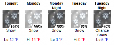
It’s going to be bone chilling cold over the next several days. I’m looking at the NWS forecasts right now for Snowshoe and they are showing a high of 9 degrees for Tuesday. 9! That’s crazy! High temperatures closer to home here in NC are forecasted to be in the teens. Like I said, it’s going to be a shock to the system, especially considering the mild weather we’ve had so far this year. 
<<< The NWS forecast for Snowshoe over the next few days. Yeah, it’s going to be COLD!
In addition to the cold temperatures, natural snowfall is also in the forecast. Ray Russell is forecasting 3-6 inches for the higher elevations here in North Carolina. The most recent NAM model is showing 4-8 inches up into West Virginia. So, as I alluded to yesterday, this isn’t a HUGE snow event, but it will be welcomed with open arms nonetheless. My drive up to Boone on Tuesday morning should be fairly interesting.
This cold blast will definitely jump start the season for the ski areas here in the Southeast. I’m pretty stoked to think about what they will look like come next weekend. Right now, there are 134 runs open for skiing and snowboarding in the region and there are only 5 ski areas that have at least half of the mountain open. We should see those figures jump up CONSIDERABLY over the next several days. The ski areas have somehow managed to stay open this year with only brief windows of opportunity to make snow and pretty much each time they were starting from scratch. This time around there is a lot more snow on the ground so the transformation will be even more dramatic!
Not much has changed today in terms of open terrain in the region, so I won’t go over each resort. I don’t like to do that every day as it can become a bit redundant I feel like. Head on over to the Ski Reports page though for all the detailed info for each ski area.
Mike will be back tomorrow to do the report, so I will talk to you guys on Tuesday morning!
Email me your comments, thoughts, photos, vids or anything else you like at [email protected]