Its official, Winter Storm Vulcan is coming. But, we have a pretty slight chance of receiving snow from this one as it really hits the North and North East more than us. The Maryland, West Virginia, and Virginia resorts have the best chance, but a slight one at only 30%. What this will bring to use however is a shot of cold air. Now, we don’t expect the slopes to fire up the guns (Snowshoe might), but it will at least prevent more of the snow from trickling down the mountain for a day or so. Herb Stevens, the Skiing Weatherman, has an update for us you can see here.
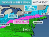
Now with what I just said in mind, Ober Galtinburg has been issued a Special Weather Statement by the NWS.
… WINTRY CONDITIONS RETURNING WEDNESDAY AFTERNOON AND WEDNESDAY NIGHT… … STRONG AND GUSTY WINDS WEDNESDAY AND WEDNESDAY NIGHT…
A STRONG COLD FRONT WILL MOVE ACROSS THE SOUTHERN APPALACHIANS WEDNESDAY PULLING MUCH COLDER AIR AND WINDY CONDITIONS INTO THE REGION. A FEW THUNDERSTORMS MAY ACCOMPANY THE FRONT AS IT QUICKLY MOVES EAST ACROSS THE AREA WEDNESDAY MORNING. HIGHS WEDNESDAY… BETWEEN THE UPPER 50S AND MIDDLE 60S… WILL OCCUR IN THE MORNING HOURS… THEN PLUMMET INTO THE 30S AND 40S DURING THE AFTERNOON AND EARLY EVENING.
STRONG AND GUSTY WESTERLY WINDS BETWEEN 20 AND 30 MPH WILL DEVELOP WEDNESDAY WITH GUSTS UP TO 45 MPH POSSIBLE. THE GUSTY WINDS WILL CONTINUE INTO WEDNESDAY EVENING.
THE RETURN OF COLDER AIR WILL CHANGE THE RAIN TO SNOW SHOWERS OVER THE HIGHER ELEVATIONS WEDNESDAY… GENERALLY AT OR ABOVE 2500 FEET. SNOW ACCUMULATIONS OF 1 TO 3 INCHES ARE POSSIBLE OVER THE FAR EASTERN TENNESSEE MOUNTAINS AND MOUNTAINS OF SOUTHWEST VIRGINIA WEDNESDAY AFTERNOON AND WEDNESDAY NIGHT.
FLURRIES OR LIGHT SNOW SHOWERS WILL BE POSSIBLE ACROSS THE REST OF THE AREA LATE WEDNESDAY AFTERNOON AND EVENING… BUT LITTLE TO NO ACCUMULATION IS EXPECTED.
So maybe there is more to this than we think. It will be interesting to see how this plays out. The storm of last week was supposed to only drop a couple inches of snow and then we wake up Friday morning to Appalachian Ski Mountain receiving 8” of fresh powdery snow.
The snow reports were very easy to update this morning – about all that changed was the morning temps, and they’re up by the way. Appalachian lost 2-6” of base skiing and riding on a 34-70” this morning. Appalachian’s Alpine Ski Shop is doing their end of year sale.
All Clothing 20-30% Off
All 13-14 Ski Boots & Skis 40% off
All Helmets &' Select' Goggles (Spy, Electric, Dragon. Smith, & Anon) – 30% off
Snowboard Equipment 15-25 % off
And if you print out the coupon below and bring it with you you’ll get an additional 10% off!

Cataloochee is down 2” to 44-74”. Cataloochee is having their Bangers and Mash Pre Patty's Day Rail Jam on Friday. You can check out the details here.
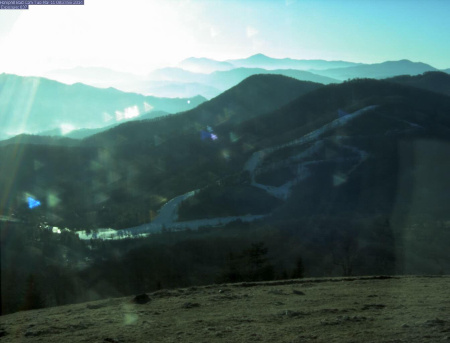
Awesome shot of Cataloochee this morning
Additionally, both Beech and Sugar are down 2” as well with Beach hosting skiers and riders on their 30-84” base, while at Sugar you’ll be riding on 30-88”.
Ober is down 2” today as well with 36-44” on the mountain, and finally Massanutten is down 4” to about 40”.
Massanutten is having Heroes on the Hill on Sunday where Active, Non-Active, Veterans, and their dependents receive a free slope-use ticket. Bravo Zulu!
That’s about it for today. If you are fortunate enough to hit the slopes today you will find more sun than you can shake a stick at with highs in the 60’s to 70’s at Ober.
Take Care!
 Tim Bahlke
Drop me an email at [email protected] to let me know what you think or with suggestions on what we could be doing better.